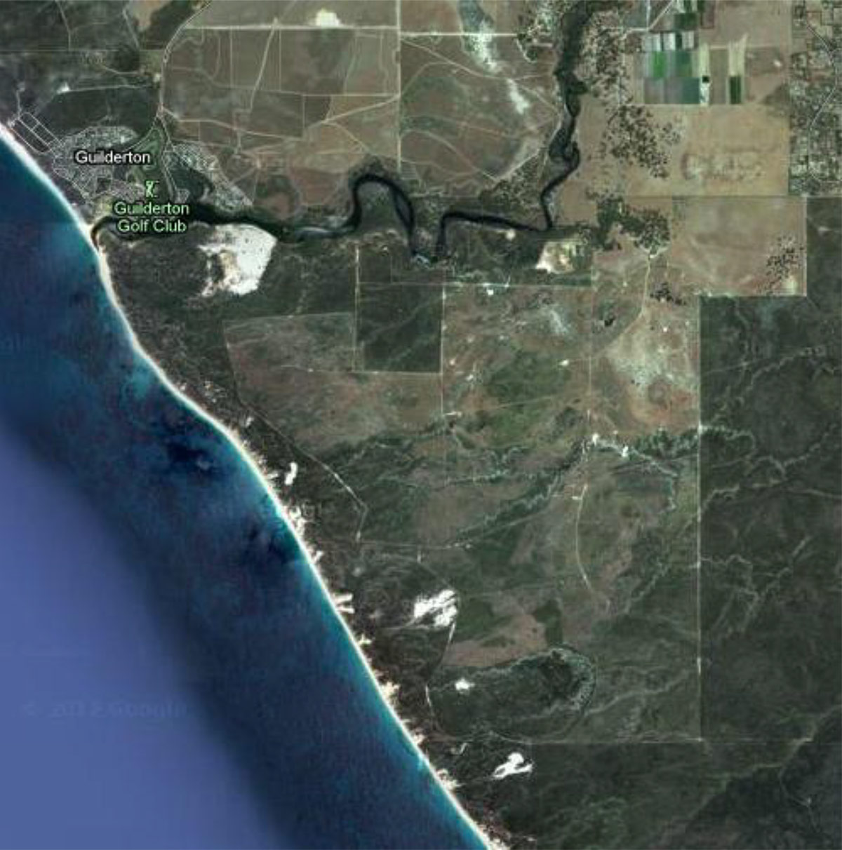
Friends of Moore River Estuary are a group of people who are amazed at how healthy Moore River Estuary remains, and wish to protect it.
Less than 100kms from Perth, with many new northern suburbs even closer, the pressure on the estuary for recreation is great. In the Rural Shire of Gingin, the estuary is small and we believe that all usage should always be eco-based. That means only development that won’t destroy or severely impact the natural environment.
We especially oppose urbanisation in a suburb at Moore River South, as proposed by Plunkett’s Moore River Company.
We have been involved since the beginning of the proposal for this development and will continue to monitor all plans that affect the estuary. Much of this website describes our aims and efforts so far.
FOMRE works with the Guilderton Community Association, Lower Moore River Working Group, Moore Catchment Council, Gingin Water Group and Northern Agricultural Catchment Council on projects that affect the river.
The latest action is, with the support of NACC and Dept of Water, to undertake water quality monitoring of the estuary. This project will collect valuable data about the river’s health and the information will also assist Gingin Water Group who are sampling further upriver.
We welcome everyone who wishes to see the estuary protected for the future. We always need new energy and new ideas. Please contact us for more information or to join us.
We hope you enjoy the place as much as we do!
After many years of frustration, the Friends of Moore River Estuary would like to remind you why this development should never proceed.
Unwise Shire approval in 1995 is the root of today’s problem
In the early 1990’s Alan Mappin was employed as the Planner for both Gingin Shire and Mr Plunkett. At that time the Shire’s population projections for Guilderton were 30,000 people (15,000 each side of the river). Amendment 22 was approved, and the land owned by Plunkett was rezoned from Rural to Urban, with no conditions, on Mr Mappin’s advice. Our recommendations for environmental assessments at the time were ignored.
Population Numbers and Infrastructure
In 2015, the population in the rural Shire of Gingin is about 5,000 people. According to their website, projections for 2031 are for about 8,000 people, total. Lancelin is the logical place for this coastal growth. There is already infrastructure in place and urban developments are approved and proceeding.
The population of Guilderton is still little more than 100 people. It remains a ‘holiday village’, with growth potential to the north and east. The surrounding estates are all ‘rural residential’. Services would be best provided to Lower Coastal Communities more centrally than here, in this ‘cul-de-sac’, cornered by the river and the ocean. West Woodridge would be an appropriate name for this proposed suburb.
2000 Outline Development Plan Rejected
The Outline Development Plan (ODP) that was approved in 2000, for 13,500 people, was then soundly rejected at subdivision stage by WAPC. That ruling was upheld by the State Appeals Tribunal.
Gingin Coast Structure Plan Recommends Reversion to ‘Rural’
In 2006, after years of extensive planning and environmental studies, the Gingin Coast Structure Plan was adopted by WAPC. It recommended that this land be zoned back to ‘rural’ and that the land be investigated as a Recreation and Tourism Node. This recommendation was not acted upon by the Shire as it was threatened with legal action by the proponent.
Minister Day Intervenes
In 2009, the newly elected Minister Day, reviewed the resulting confusion and sought a compromise by approving the urban zoning, but with the development size, reduced by 60%.
Revised ODP
This was the time for a new ODP, subject to the new knowledge now available. Instead MRC presented a ‘revised ODP’ to circumvent the current assessment and approval standards.
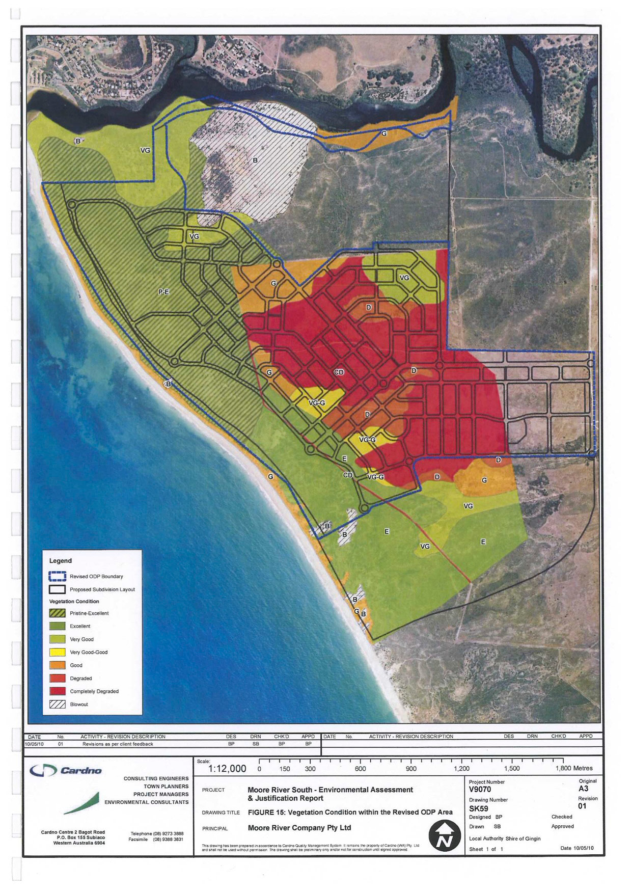
FOMRE thinks that the Revised ODP is a vastly inadequate document with deficiencies in many areas. As this ODP now stands, most of the detailed studies and reports that need to be included with this ODP have been deferred to some unknown time in the future.
Revised ODP Approved 2013
The current ODP was approved by the Shire and WAPC in 2013. Promises of ‘state of the art’ sewerage, uncertain water and power supply, ‘space’ for community facilities (to be provided by others, if ever required) are among the inadequacies. There is no local employment for 5,000 residents, nor existing nearby facilities.
The ODP’s described development is no more than an isolated suburb, north of Perth’s metropolitan limit that, in line with current planning standards, should stand no chance of approval, as it runs counter to many State Planning Policies.
That ‘the proposed development will occur over an extended period of time’ makes it clear that it is a long way from being ‘ready’. Any ODP should only be approved when it is imminent.
The site also sits over the northern area of the Gnangara Groundwater System. Water access, as the proponent suggests, remains an unproven and expensive idea.
Revised ODP is catastrophic for the environment
While MRC owns 2,000 hectares and much of this has been grazed for 60 years and is partially degraded, the ODP 557 hectares (and the 452 of the current plan) include Pristine and Excellent, Very Good and Good remnant bushland that would be destroyed by urbanization, inclusive of the ‘tourist resort’ development.
This remnant bushland connects with Wilbinga Reserve and is home to the threatened Carnaby’s Cockatoo and Graceful Sun Moth as well as many species of fauna and flora, as described in the ODP appendices.
That MRC can tell you that this land is of ‘No environmental sensitivity’, when it actually requires referral to the Federal EPBC, astonishes us, and is a perfect example of the ignorance MRC is hoping to get away with.
The Moore River Estuary is no Peel Harvey Estuary. It is a small and fragile area that would be severely degraded by the pressure of 5,000 more residents nearby who would surely wish to access it for recreation, even if they are living a kilometre away.
Bad Planning
The nearest ocean access, aquatic and fitness facilities, aged care, child care, health and medical services, education and employment; are all in the metropolitan area to the south. That is also the place for any urban development. Moore River South is no place for a suburb.
We trust that the above provides the information you need to understand why this project must now be rejected and that you will also oppose this unwise plan.